| # [A] | Name of island | Area | Population | Coordinates | Notes |
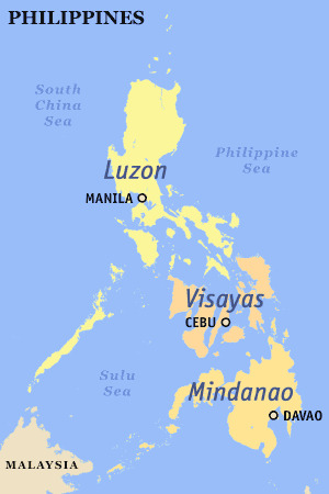
| 1 | Luzon | 109,965 km2 (42,458 sq mi) | 64,260,312 | 15°59′59″N 121°00′00″E / 15 °N 121 °E / 15 ; 121 (Luzon) | 15th largest island and 4th most populated island in the world |
| 2 | Mindanao | 97,530 km2 (37,657 sq mi) | 25,537,691 | 7°41′42″N 124°15′04″E / 7 °N 124 °E / 7 ; 124 (Mindanao) | 19th largest island in the world |
| 3 | Samar | 13,429 km2 (5,185 sq mi) | 1,880,020 | 11°48′00″N 125°00′43″E / 11 °N 125 °E / 11 ; 125 (Samar) | Largest island entirely within one region |
| 4 | Negros | 13,310 km2 (5,139 sq mi) | 4,414,131 | 10°01′34″N 122°58′01″E / 10 °N 122 °E / 10 ; 122 (Negros) | |
| 5 | Palawan | 12,189 km2 (4,706 sq mi) | 886,308 | 9°30′00″N 118°30′00″E / 9 °N 118 °E / 9 ; 118 (Palawan) | Largest island entirely within one province |
| 6 | Panay | 12,011 km2 (4,637 sq mi) | 4,477,247 | 11°10′26″N 122°30′14″E / 11 °N 122 °E / 11 ; 122 (Panay) | |
| 7 | Mindoro | 10,572 km2 (4,082 sq mi) | 1,331,473 | 12°52′15″N 120°55′40″E / 12 °N 120 °E / 12 ; 120 (Mindoro) | |
| 8 | Leyte | 7,368 km2 (2,845 sq mi) | 2,388,518 | 10°50′01″N 124°50′00″E / 10 °N 124 °E / 10 ; 124 (Leyte) | |
| 9 | Cebu | 4,468 km2 (1,725 sq mi) | 3,917,423 | 10°19′42″N 123°48′22″E / 10 °N 123 °E / 10 ; 123 (Cebu) | Island province |
| 10 | Bohol | 3,821 km2 (1,475 sq mi) | 1,313,560 | 9°50′41″N 124°12′49″E / 9 °N 124 °E / 9 ; 124 (Bohol) | Island province |
| 11 | Masbate | 3,268 km2 (1,262 sq mi) | 706,897 | 12°15′01″N 123°30′00″E / 12 °N 123 °E / 12 ; 123 (Masbate) | Largest of island in Masbate province |
| 12 | Catanduanes | 1,523 km2 (588 sq mi) | 260,964 | 13°48′31″N 124°13′24″E / 13 °N 124 °E / 13 ; 124 (Catanduanes) | Island province |
| 13 | Basilan | 1,265 km2 (488 sq mi) | 459,367 | 6°35′28″N 121°59′19″E / 6 °N 121 °E / 6 ; 121 (Basilan) | Island province; largest island of the Sulu Archipelago |
| 14 | Marinduque | 952 km2 (368 sq mi) | 234,521 | 13°23′06″N 121°58′52″E / 13 °N 121 °E / 13 ; 121 (Marinduque) | Island province |
| 15 | Busuanga | 890 km2 (344 sq mi) | 73,849 | 12°08′42″N 120°05′41″E / 12 °N 120 °E / 12 ; 120 (Busuanga) | Largest of the Calamian Islands |
| 16 | Jolo | 869 km2 (336 sq mi) | 530,000 | 5°58′24″N 121°09′00″E / 5 °N 121 °E / 5 ; 121 (Jolo) | Part of the Sulu Archipelago |
| 17 | Tablas | 839 km2 (324 sq mi) | 164,012 | 12°24′20″N 122°03′51″E / 12 °N 122 °E / 12 ; 122 (Tablas) | |
| 18 | Dinagat | 802 km2 (310 sq mi) | 106,951 | 10°13′30″N 125°35′41″E / 10 °N 125 °E / 10 ; 125 (Dinagat) | Island province |
| 19 | Polillo | 629 km2 (243 sq mi) | 64,802 | 14°50′34″N 121°55′45″E / 14 °N 121 °E / 14 ; 121 (Polillo) | |
| 20 | Guimaras | 605 km2 (234 sq mi) | 174,613 | 10°34′47″N 122°36′03″E / 10 °N 122 °E / 10 ; 122 (Guimaras) | Island province |
| 21 | Tawitawi | 581 km2 (224 sq mi) | 82,582 | 5°11′52″N 120°02′00″E / 5 °N 120 °E / 5 ; 120 (Tawitawi) | Island province; part of the Sulu Archipelago |
| 22 | Biliran | 536 km2 (207 sq mi) | 171,612 | 11°35′01″N 124°28′00″E / 11 °N 124 °E / 11 ; 124 (Biliran) | Island province |
| 23 | Sibuyan | 465 km2 (180 sq mi) | 59,274 | 12°23′10″N 122°33′40″E / 12 °N 122 °E / 12 ; 122 (Sibuyan) | |
| 24 | Siargao | 437 km2 (169 sq mi) | 94,273 | 9°54′19″N 126°04′00″E / 9 °N 126 °E / 9 ; 126 (Siargao) | |
| 25 | Burias | 424 km2 (164 sq mi) | 90,300 | 12°52′54″N 123°12′28″E / 12 °N 123 °E / 12 ; 123 (Burias) | |
| 26 | Culion | 389 km2 (150 sq mi) | 20,139 | 11°49′09″N 119°57′38″E / 11 °N 119 °E / 11 ; 119 (Culion) | 2nd largest of the Calamian Islands |
| 27 | Siquijor | 337 km2 (130 sq mi) | 95,984 | 9°11′51″N 123°35′47″E / 9 °N 123 °E / 9 ; 123 (Siquijor) | Island province |
| 28 | Ticao | 334 km2 (129 sq mi) | 95,129 | 12°30′58″N 123°41′41″E / 12 °N 123 °E / 12 ; 123 (Ticao) | |
| 29 | Dumaran | 322 km2 (124 sq mi) | | 10°32′50″N 119°52′23″E / 10 °N 119 °E / 10 ; 119 (Dumaran) | |
| 30 | Balabac | 319 km2 (123 sq mi) | | 7°56′32″N 117°00′30″E / 7 °N 117 °E / 7 ; 117 (Balabac) | |
| 31 | Samal | 301 km2 (116 sq mi) | 104,123 | 7°02′52″N 125°44′39″E / 7 °N 125 °E / 7 ; 125 (Samal) | |
| 32 | Sibutu | 285 km2 (110 sq mi) | 30,387 | 4°46′40″N 119°28′35″E / 4 °N 119 °E / 4 ; 119 (Sibutu) | |
| 33 | Camiguin | 255 km2 (98 sq mi) | 88,478 | 9°10′26″N 124°42′34″E / 9 °N 124 °E / 9 ; 124 (Camiguin) | Island province |
| 34 | Calayan | 196 km2 (76 sq mi) | 8,919 | 19°16′N 121°29′E / 19 °N 121 °E / 19 ; 121 (Calayan) | Largest of the Babuyan Islands |
| 35 | Olutanga | 194 km2 (75 sq mi) | 87,078 | 7°22′00″N 122°52′54″E / 7 °N 122 °E / 7 ; 122 (Olutanga) | |
| 36 | Alabat | 192 km2 (74 sq mi) | 41,822 | 14°07′06″N 122°03′05″E / 14 °N 122 °E / 14 ; 122 (Alabat) | |
| 37 | Panaon | 191 km2 (74 sq mi) | 57,703 | 10°03′05″N 125°12′45″E / 10 °N 125 °E / 10 ; 125 (Panaon) | |
| 38 | Mapun | 181 km2 (70 sq mi) | 26,597 | 7°00′N 118°30′E / 7 °N 118 °E / 7 ; 118 (Mapun) | Formerly known as Cagayan de Tawi-tawi |
| 39 | Camiguin | 166 km2 (64 sq mi) | | 18°50′00″N 121°51′36″E / 18 °N 121 °E / 18 ; 121 (Camiguin) | Part of the Babuyan Islands in Luzon, and distinct from Camiguin in Mindanao |
| 40 | Bucas Grande | 128 km2 (49 sq mi) | 22,314 | 9°40′26″N 125°56′55″E / 9 °N 125 °E / 9 ; 125 (Bucas Grande) | |
| | Lubang | 125 km2 (48 sq mi) | 28,922 | 13°46′03″N 120°11′10″E / 13 °N 120 °E / 13 ; 120 (Lubang) | |
| | Linapacan | 120 km2 (46 sq mi) | 15,668 | 11°30′N 119°54′E / 11 °N 119 °E / 11 ; 119 (Linapacan) | Largest island in the group of islands in Linapacan Strait. |
| | Bugsuk | 119 km2 (46 sq mi) | | 8°15′15″N 117°18′29″E / 8 °N 117 °E / 8 ; 117 (Bugsuk) | |
| | Bantayan | 108 km2 (42 sq mi) | 120,447 | 11°13′07″N 123°44′55″E / 11 °N 123 °E / 11 ; 123 (Bantayan) | |
| | Pacijan | 106 km2 (41 sq mi) | | 10°40′N 124°20′E / 10 °N 124 °E / 10 ; 124 (Pacijan) | Part of Camotes Islands group |
| | Homonhon | 105 km2 (41 sq mi) | 4,211 | 10°45′21″N 125°44′21″E / 10 °N 125 °E / 10 ; 125 (Homonhon) | |
| | Babuyan Claro | 100 km2 (39 sq mi) | 1,423 | 19°31′20″N 121°57′13″E / 19 °N 121 °E / 19 ; 121 (Camiguin) | Part of the Babuyan Islands |
| | Poro | 96 km2 (37 sq mi) | 36,508 | 10°40′20″N 124°27′22″E / 10 °N 124 °E / 10 ; 124 (Poro) | Part of Camotes Islands group |
| | Patnanongan | 92 km2 (36 sq mi) | 14,606 | 14°47′01″N 122°10′40″E / 14 °N 122 °E / 14 ; 122 (Patnanongan) | |