| Name of the neighborhood | Limits south to north and east to west |
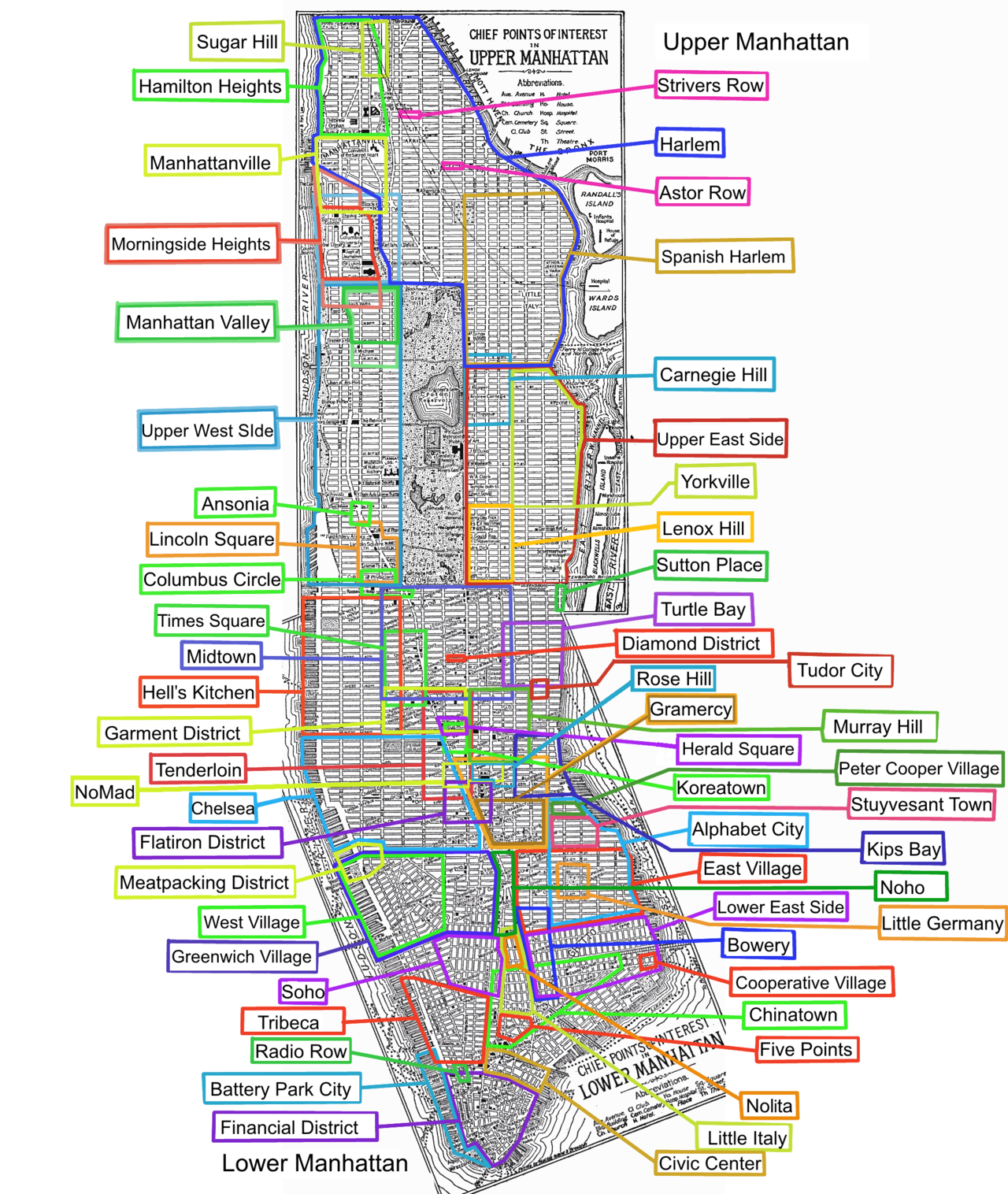
| Upper Manhattan | Above 96th Street |
| Marble Hill MN01 | The neighborhood is located across the Harlem River from Manhattan Island and has been connected to The Bronx and the rest of the North American mainland since 1914, when the former course of the Spuyten Duyvil Creek was filled in. |
| Inwood MN02 | Above Dyckman Street |
| Fort George (part of Washington Heights) | East of Broadway between West 181st Street and Dyckman Street |
| Washington Heights MN35 & 36 | West 155th Street to Dyckman Street |
| Hudson Heights (part of Washington Heights) | West 181st Street to Fort Tryon Park west of Broadway |
| West Harlem | West 125th to West 155th Streets; St. Nicholas Avenue to Broadway |
| Hamilton Heights (part of Harlem) (MN04 | West 135th to West 155th Streets; Broadway to the Hudson River |
| Manhattanville MN06 | West 125th to West 135th Streets; St. Nicholas Avenue to the Hudson River |
| Morningside Heights MN09 | West 110th to West 125th Streets; Morningside to Riverside drives |
| Central Harlem MN03 & 11 | 110th to 155th Streets; Park to St. Nicholas avenues |
| Harlem | 96th to 141st Streets (east), 110th to 155th Streets (central), 125th to 155th streets (west) |
| St. Nicholas Historic District, aka Strivers' Row (Central Harlem) | West 137th to West 138th Streets; 7th to 8th avenues |
| Astor Row (Central Harlem) | Centered at West 130th Street |
| Sugar Hill (Central Harlem) | West 145th to West 155th streets; Edgecombe to Amsterdam avenues |
| Marcus Garvey Park, Mount Morris Historical District | 120th to 124th Streets; Madison to 5th avenues |
| Le Petit Senegal (Little Senegal) | 116th Street east of Morningside Park |
| East Harlem (Spanish Harlem) MN33 & 34 | 96th to 141st streets; the East River to 5th Avenue |
| Upper East Side MN40 | East 59th to 96th streets; the East River to 5th Avenue (and 96th to 110th streets along 5th Avenue) |
| Lenox Hill MN31 | 60th to 77th streets; the East River to Park Avenue |
| Carnegie Hill | 86th to 98th streets; 3rd to 5th avenues (centered at East 91st Street and Park Avenue) |
| Yorkville MN32 | East 79th to East 96th streets; the East River to 3rd Avenue (centered at East 86th Street and 3rd Avenue) |
| Upper West Side MN12 | West 59th to West 110th Streets; Central Park West to the Hudson River |
| Manhattan Valley, Bloomingdale District | West 96th to West 110th streets; Central Park West to Broadway |
| Lincoln Square MN14 (once San Juan Hill) | West 59th to West 66th streets; Columbus Avenue to Broadway |