| Beaufort number | Description | Wind speed | Wave height | Sea conditions | Land conditions | Sea conditions (photo) | Associated warning flag |
| 0 | Calm | < 1 knot < 1 mph < 1 km/h 0–0 m/s | 0 ft 0 m | Sea like a mirror | Smoke rises vertically | | |
| 1 | Light air | 1–3 knots 1–3 mph 1–5 km/h 0 –1 m/s | 0–1 ft 0–0 m | Ripples with appearance of scales are formed, without foam crests | Direction shown by smoke drift but not by wind vanes | | |
| 2 | Light breeze | 4–6 knots 4–7 mph 6–11 km/h 1 –3 m/s | 1–2 ft 0 –0 m | Small wavelets still short but more pronounced; crests have a glassy appearance but do not break | Wind felt on face; leaves rustle; wind vane moved by wind | | |
| 3 | Gentle breeze | 7–10 knots 8–12 mph 12–19 km/h 3 –5 m/s | 2–4 ft 0 –1 m | Large wavelets; crests begin to break; foam of glassy appearance; perhaps scattered white horses | Leaves and small twigs in constant motion; light flags extended | | |
| 4 | Moderate breeze | 11–16 knots 13–18 mph 20–28 km/h 5 –7 m/s | 3 –6 ft 1–2 m | Small waves becoming longer; fairly frequent white horses | Raises dust and loose paper; small branches moved | | |
| 5 | Fresh breeze | 17–21 knots 19–24 mph 29–38 km/h 8–10 m/s | 6–10 ft 2–3 m | Moderate waves taking a more pronounced long form; many white horses are formed; chance of some spray | Small trees in leaf begin to sway; crested wavelets form on inland waters | | |
| 6 | Strong breeze | 22–27 knots 25–31 mph 39–49 km/h 10 –13 m/s | 9–13 ft 3–4 m | Large waves begin to form; the white foam crests are more extensive everywhere; probably some spray | Large branches in motion; whistling heard in telegraph wires; umbrellas used with difficulty | | |
| 7 | Moderate gale, near gale | 28–33 knots 32–38 mph 50–61 km/h 13 –17 m/s | 13–19 ft 4–5 m | Sea heaps up and white foam from breaking waves begins to be blown in streaks along the direction of the wind; spindrift begins to be seen | Whole trees in motion; inconvenience felt when walking against the wind | | |
| 8 | Gale, fresh gale | 34–40 knots 39–46 mph 62–74 km/h 17 –20 m/s | 18–25 ft 5 –7 m | Moderately high waves of greater length; edges of crests break into spindrift; foam is blown in well-marked streaks along the direction of the wind | Twigs break off trees; generally impedes progress | | |
| 9 | Strong/severe gale | 41–47 knots 47–54 mph 75–88 km/h 20 –24 m/s | 23–32 ft 7–10 m | High waves; dense streaks of foam along the direction of the wind; sea begins to roll; spray affects visibility | Slight structural damage (chimney pots and slates removed) | | |
| 10 | Storm, whole gale | 48–55 knots 55–63 mph 89–102 km/h 24 –28 m/s | 29–41 ft 9–12 m | Very high waves with long overhanging crests; resulting foam in great patches is blown in dense white streaks along the direction of the wind; on the whole the surface of the sea takes on a white appearance; rolling of the sea becomes heavy; visibility affected | Seldom experienced inland; trees uprooted; considerable structural damage | | |
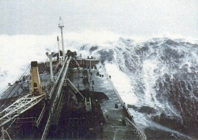
| 11 | Violent storm | 56–63 knots 64–72 mph 103–117 km/h 28 –32 m/s | 37–52 ft 11 –16 m | Exceptionally high waves; small- and medium-sized ships might be for a long time lost to view behind the waves; sea is covered with long white patches of foam; everywhere the edges of the wave crests are blown into foam; visibility affected | Very rarely experienced; accompanied by widespread damage | | |
| 12 | Hurricane-force | ≥ 64 knots ≥ 73 mph ≥ 118 km/h ≥ 32 m/s | ≥ 46 ft ≥ 14 m | The air is filled with foam and spray; sea is completely white with driving spray; visibility very seriously affected | Devastation | | |