| Number | Length (km) | Length (mi) | Southern or western terminus | Northern or eastern terminus | Local names | Formed | Removed | Notes |
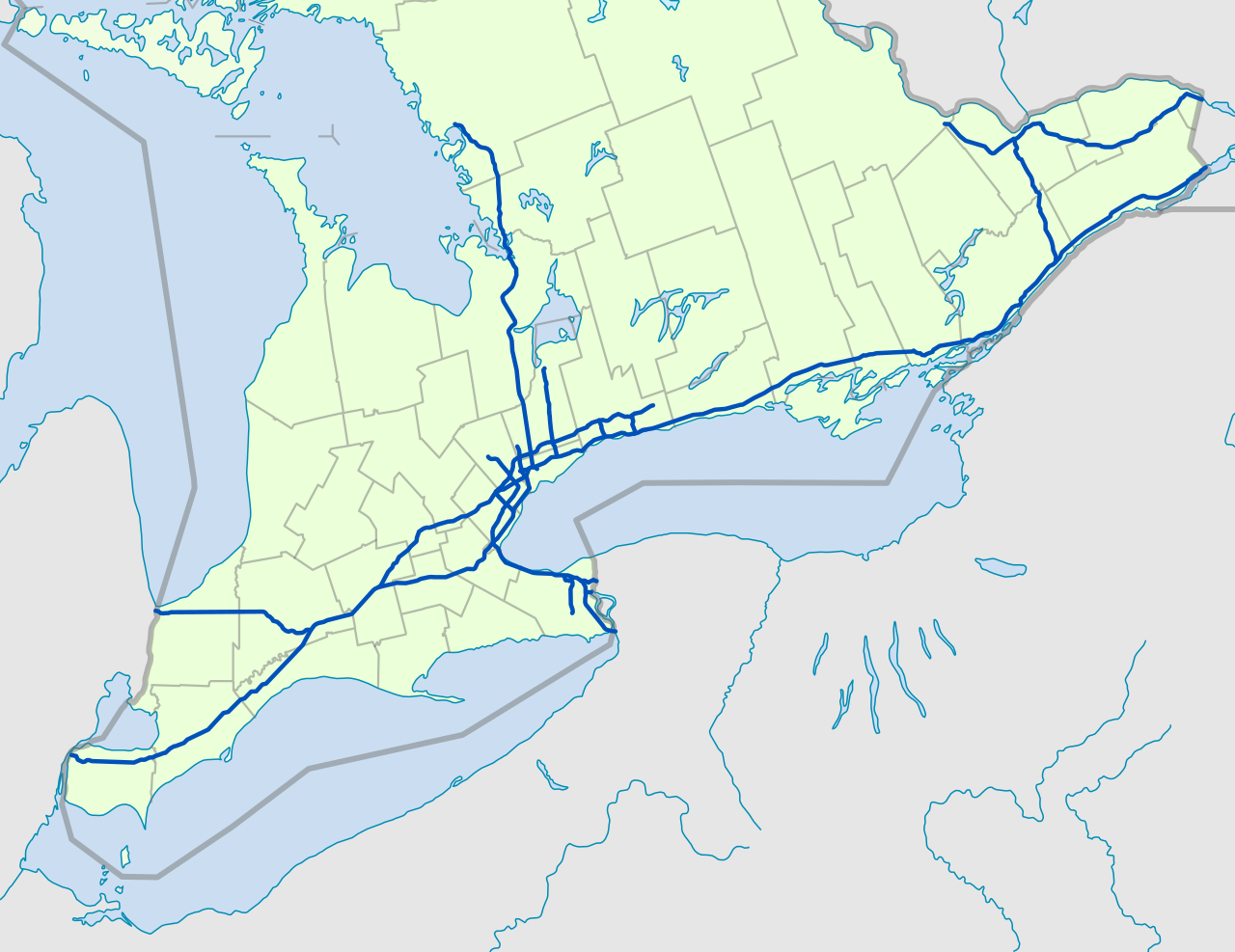
| Highway 400 | 226 | 140 | Maple Leaf Drive in Toronto (continues as Black Creek Drive) | Highway 69 in Carling | Toronto–Barrie Highway | 01952-07-011952 | current | Scheduled for extension to Sudbury. |
| Highway 401 | 828 | 514 | Ojibway Parkway in Windsor | A-20 towards Montreal, QC | Macdonald–Cartier Freeway, Rt. Hon. Herb Gray Parkway, Highway of Heroes | 01952-07-011952 | current | Busiest highway in North America. Scheduled for extension to American border following completion of the Gordie Howe International Bridge. |
| Highway 402 | 102 | 63 | I-69 / I-94 at Canada–United States border on Blue Water Bridge in Point Edward | Highway 401 in London | | 01953-01-011953 | current | |
| Highway 403 | 125 | 77 | Highway 401 near Woodstock | Highway 401 / Highway 410 in Mississauga | Chedoke Expressway, Alexander Graham Bell Parkway | 01963-12-011963 | current | |
| Highway 404 | 50 | 31 | Highway 401 / DVP in Toronto | Regional Road 8 (Woodbine Avenue) in East Gwillimbury | | 01977-01-011977 | current | |
| Highway 405 | 8 | 5 | Queen Elizabeth Way – St. Catharines | I-190 at Canada–United States border on Queenston-Lewiston Bridge towards Lewiston, NY | General Brock Parkway | 01963-09-111963 | current | |
| Highway 406 | 26 | 16 | East Main Street in Welland | Queen Elizabeth Way in St. Catharines | | 01965-12-071965 | current | |
| 407 ETR / Highway 407 | 151 | 94 | Highway 403 / Queen Elizabeth Way in Burlington | Highway 35 / Highway 115 in Clarington | | 01997-06-071997 | current | Freeway divided into two sections: 407 ETR, with the latter tolled and privately operated, and Highway 407E; tolls removed on Highway 407E effective June 1, 2025 |
| Highway 409 | 5 | 3 | Pearson Airport in Mississauga | Highway 401 in Toronto | Belfield Expressway | 01978-08-251978 | current | |
| Highway 410 | 20 | 12 | Highway 401 / Highway 403 in Mississauga | Highway 10 (Hurontario Street) in Caledon | | 01978-11-151978 | current | |
| Highway 412 | 10 | 6 | Highway 401 in Whitby | Highway 407 in Whitby | West Durham Link | 02016-06-202016 | current | Route number assigned February 5, 2015; tolls removed effective April 5, 2022 |
| Highway 416 | 76 | 47 | Highway 401 towards Brockville | Highway 417 in Ottawa | Veterans Memorial Highway | 01999-09-231999 | current | |
| Highway 417 | 192 | 119 | Highway 17 in Arnprior | A-40 (TCH) towards Montreal, QC | Queensway, Trans-Canada Highway | 01971-01-011971 | current | Unlike most freeways, kilometre posts are numbered east to west. |
| Highway 418 | 12 | 8 | Highway 401 in Clarington | Highway 407 in Clarington | East Durham Link | 02019-12-092019 | current | Route number assigned February 5, 2015; tolls removed effective April 5, 2022 |
| Highway 420 | 3 | 2 | Regional Road 98 (Montrose Road) | US 62 at Canada–United States border on Rainbow Bridge in Niagara Falls | Niagara Veterans Memorial Highway | 01941-11-011941 | current | |
| Highway 427 | 27 | 17 | Queen Elizabeth Way/Gardiner Expressway in Toronto | Regional Road 25 (Major Mackenzie Drive) in Vaughan | | 01971-12-041971 | current | 6 (4 mi) extension to Regional Road 25 (Major Mackenzie Drive) opened September 18, 2021 |
| Queen Elizabeth Way | 139 | 86 | I-190 at Canada–United States border on Peace Bridge in Fort Erie | Highway 427/Gardiner Expressway in Toronto | | 01937-12-311937 | current | Internally referred to as Highway 451 in the Ontario Ministry of Transportation |